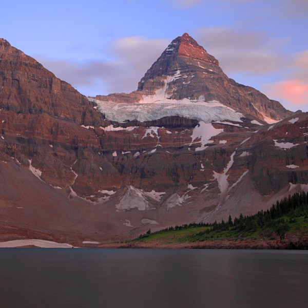
 Mount Assiniboine and Lake Magog at twilight, seen from near the Lake
Magog campground
Mount Assiniboine and Lake Magog at twilight, seen from near the Lake
Magog campground
Ideas for hikes in the Canadian Rockies
The Rockies are North America's quintessential mountain range, and although the Sierras,
Alaska, the Cascades and British Columbia's Coast Range all offer wonderous scenery, the Rockies
are hard to beat for hiking. The range stretches from Colorado, where there are dozens of
hikeable 14,000 foot-high peaks, into Canada, where ongoing glaciation provides some of the
most dramatic and iconic landscapes. This page provides a few suggestions toward great
hikes I've enjoyed in the Canadian Rockies.
Short backpacks: Mount Assiniboine and the Berg Lake trail
Lists of the best backpacking trips in the Canadian Rockies invariably feature hikes to
Lake Magog (in Mount Assiniboine provincial park), the Skyline trail (in Jasper national
park), and the Berg Lake trail (in Mount Robson provincial park) among the best of the
best. I've done two of these trips, and they both lived up to their reputation as
unmissable hiking experiences.
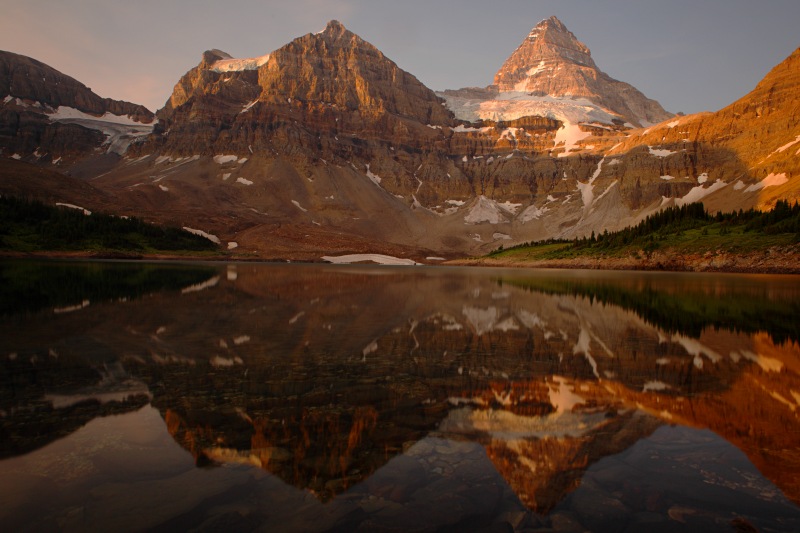 Mount Assiniboine at dawn from Lake Magog
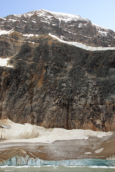
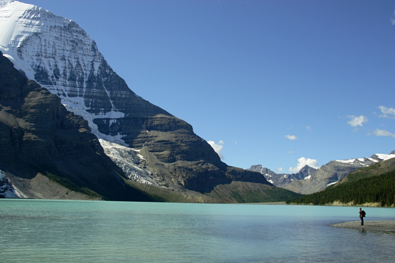 The view of Mount Robson's Emperor Face from Berg Lake
Lake Magog, Mount Assiniboine Provincial Park:
Lake Magog lies at the heart of
Mount Assiniboine Provincial Park, in the southern part of the Canadian Rockies. Options to
see the stunningly beautiful region surrounding the mountain cater for pretty much everyone:
you can helicopter, ski or hike in along numerous trails, and enjoy either the luxury
of the Mount Assiniboine Lodge or the more basic charms of the backcountry campground. In 2009, my brother and
I hiked
to the lake out-and-back along the 18 mile trail that starts at the Sunshine Village
ski area in Banff National Park (at high elevation) and proceeds to the lake via Citadel Pass. The hike in, although
scenic from the start, does not compare to the beauty around Lake Magog. I'd recommend not
dawdling and going at least as far as Lake Og (13 miles), and ideally all the way to Lake Magog, before
camping. Be aware though that while Citadel Pass is a trifling obstable
on the way in, it's much stiffer
on the way back! You might consider either breaking the return
into shorter pieces by camping at Lake Og or, with a shuttle, hiking out via a different route, such as the
Wonder Pass trail which returns to the Mount Shark trailhead.
However you get there, Lake Magog is a magical spot. The campground occupies a forested
rise at the far end of the large lake, just above rocky beaches from where there are great views of
the peak. Dawn saw the postcard reflection of a
golden Mount Assiniboine seen in the photo above. Several day hikes are possible from
Lake Magog, so it's worth basing yourself at the campground for at least a couple of days to
explore some of the surrounding ridges and passes. Do make sure you're well protected against
bugs, which we found to be particularly dense!
Practicalities: This is an easy trip to organize. Reservations
are only needed if you plan to camp in Banff National Park near the start of the trail from Sunshine Village
(not recommended in any case), otherwise permits are issued on a self-service basis at the Lake Og and Lake
Magog campgrounds (if you arrive at Lake Magog to find the campground officially "full", which happened to
us, you'll be directed to pitch your tent on whatever flat spot you can find in an adjoining meadow). The only
booking to consider making in advance is for the Sunshine Meadows shuttle, a bus or gondola ride
from the parking lot at the base of the Sunshine Village ski area up to the meadows
where the trail starts. Taking the bus saves 4 miles of tedious road walking at either end of the trip.
The nearest towns are Banff and Canmore in Alberta.
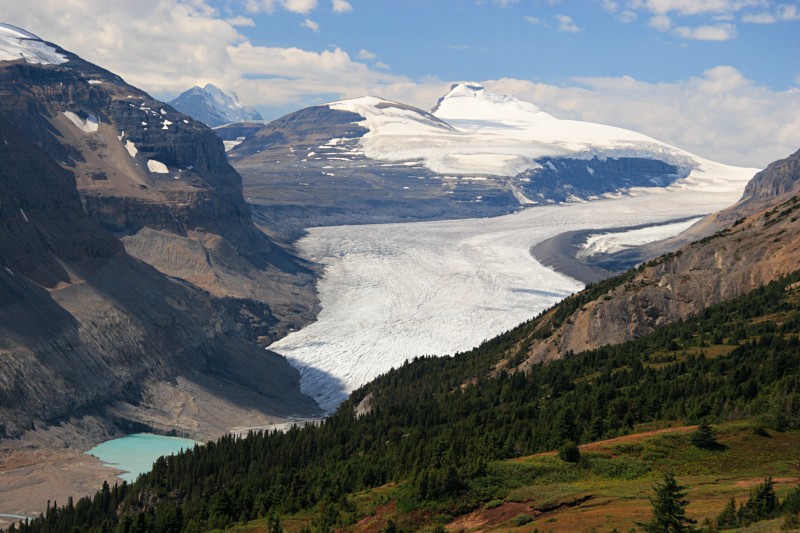
Berg Lake trail, Mount Robson Provincial Park:
Whether you day hike, backpack, or run the trail, the Berg Lake hike in British
Columbia's Mount Robson park is an amazing experience. It's my
top hike in North America. Mount
Robson is the highest peak in the Canadian Rocky Mountains (3,954m or almost 13,000 feet) and, thanks
to its isolated location at the northern extremity of the range, the most heavily glaciated.
The sight of the Berg Glacier flowing some 2,000m down from the summit snowfields into its namesake
lake is probably the single most spectacular vista in the Rockies.
Hiking to Berg Lake requires just enough effort to add value to the
view. From the trailhead, 60 miles west of Jasper along Highway 16, it's 13 miles of hiking (one way) to the Berg Lake campground and shelter near the shore
of the lake. Most people tackle this as a short backpacking trip, camping either at Berg Lake itself or
at some of the other well-situated campgrounds (especially the Emperor Falls campground) en route. The
trail is well maintained and, for the most part, only moderately difficult, though there's a stiff
section of climbing through the Robson River gorge to attain the upper Robson River Valley containing
Berg Lake. The hike is outstandingly scenic the whole way: landmarks such as Emperor Falls or the
Valley of a Thousand Falls - which if you're making good time are here mere side trips en route
to Berg Lake - would be major destinations almost anywhere else. The video below shows some of the
highlights of our trip.
Practicalities: I've hiked the
Berg Lake trail twice,
the first time as a day hike, which is not quite as crazy as it sounds because you can use mountain bikes for the first
few miles. Most people though do this as a short backpack, in which case I'd recommend camping at the Emperor Falls or Berg
Lake campgrounds. From the Berg Lake campground it's possible to take a day hike to Snowbird Pass, which yields a spectacular vista of the
Robson glacier. The main hiking season starts in mid to late June, and runs through September.
Day hikes in the Canadian Rockies
There are far too many day hiking possibilities in the Canadian Rockies for me to
make any pretense at completeness. Here, rather, are a selection of great day hikes
in the Rockies that should not disappoint. Also included are a couple of hikes just
to the west of the Rockies - in the adjoining Selkirk and Purcell mountains - that
make for an interesting and generally less crowded alternative.
Iceline trail, Yoho National Park: Yoho is one of those national parks whose single
most impressive sight - Takakkaw Falls - requires no effort to see. There's an enormous
parking lot at the end of Yoho Valley Road right at the base of the falls. At almost
400m (1200 feet) high it ranks alongside California's
Yosemite Falls during the Spring runoff as one of the best waterfalls in North America.
 Distant glaciers in Yoho
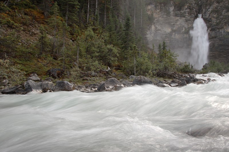 Laughing Falls, Yoho National Park
The falls are also the trailhead for the highly recommended Iceline trail, which connects with
several others to allow excellent loop hikes.
From Takakkaw Falls the trail climbs steeply to ascend the opposite valley wall from where, above treeline amid
a barren landscape of rock and vestigal glaciers, there are excellent views of the falls, the Daly glacier, and the distant
peaks that ring Lake O'Hara. Among many hiking options, the simplest is an 8 mile out-and-back along the Iceline to the
highpoint. The scenic rewards amply repay the effort required to gain some 2,000 feet. Alternatively, it's possible to
make several loops, either by descending on the Highline trail via Lake Celeste or by taking the Iceline all the way into
Little Yoho Valley. The loop options add 2 to 5 miles to the distance and pass some attractive meadows and (smaller)
waterfalls, at the expense of adding a rather tedious final trudge through the forest to get back to the trailhead.
Alpine Circuit, Lake O'Hara: The Lake O'Hara region of Yoho is a pocket-sized version
of the Canadian Rockies. All the elements of the quintessential Rocky Mountain scene are here:
emerald green glacial lakes, lush forest, barren cirques and snowy peaks. It's both beautiful and
something of a hassle to see, since unless you plan to walk 7 miles each way along the (closed) road
you need to book a shuttle and / or campsite typically many months in advance.
Once at the lake a wealth of mostly easy trails allow you to explore
some of the other lakes and viewpoints above Lake O'Hara. The best single option
is probably the 8 miles of the Lake O'Hara alpine circuit loop, which combines stretches of trail with marked
routes along rocky ledges to visit Lake Oesa, Opabin Lake and Schaffer Lake. Along the way there are
several impressive viewpoints of the lakes and valleys below, with the panoramic vista from All Souls Prospect
(above) being my personal favorite. This makes for a very enjoyable day out, though the
ledges and traverses of the alpine circuit, although scenic and adventurous, don't actually
take you anywhere you can't also go to via shorter, more direct trails.
Wilcox Pass and Parker Ridge trails: These are two short hikes that lead to
overlooks of the Athabasca and Saskatchewan glaciers.
 The view from Wilcox Pass across to Mount Athabasca
 The Saskatchewan Glacier from the Parker Ridge
The Athabasca glacier's snout lies within walking distance of the Icefields
Parkway, and there's an interpretive center just off the highway.
The Wilcox Pass
trail leads to an overlook of the glacier from a low pass on the opposite side of the road. From this elevated vantage the scale of the glacier is much more impressive than from the highway. It's a
pretty easy but highly recommended hike - about 6 miles out and back with a little over a thousand feet of elevation gain. It's
possible to continue over the pass, away from the glacier, into a high and barren alpine valley, which is extremely scenic in its own
right.
The Parker Ridge trail may yield the greatest reward for the least effort of any of the hikes off
the Icefields Parkway. A short but steep climb (about 3 miles round trip, with 900 feet of elevation gain)
leads to a spectacular reveal of the
Saskatchewan Glacier and a panorama of surrounding peaks once you crest the ridge. The trailhead
is right on the highway about 3 miles south of the boundary between Banff and Jasper National parks
at Sunwapta Pass.
Mount Fairview trail: The summit of Mount Fairview, above Lake Louise in Banff National Park, is the highest point you can reach
on a maintained trail in the Canadian Rockies. The summit
affords a great panorama that encompasses the glaciated peaks at the head of Lake Louise, snowcapped
Mount Temple, and distant glaciers that lie to the north along the Icefields Parkway. The trail leaves from the shore of Lake Louise. From
there, it's just 3.3 miles to the summit of Fairview, but 1000m vertical meters (3300 feet). The last mile is
especially stiff.
 Fairview Mountain summit, Banff
Mount Edith Cavell: Mount Edith Cavell and its hanging glacier, located less than an hour's drive south of Jasper
at the end of the Cavell Road (normally open June through October), is one of the premier drive-up attractions of Jasper National
Park. Two short hikes leave from the parking lot at the end of the road: the easy Path of Glacier loop (about one mile roundtrip)
and the Cavell Meadows Loop, which is about 5 miles long with more than a thousand feet of elevation gain. Both trails
offer great views of the mountain and the icy lake at the foot of the glacier. Longer hikes into the Tonquin Valley also depart from the Mount Edith Cavell Road,
shortly before it dead ends at the Mount Edith Cavell parking area. Camping near the Ramparts and Amethyst Lakes
is supposed to be exceptional.
 Last light on the face of Mount Edith Cavell, in Jasper National Park
Nearby hikes in the Purcell and Selkirk Mountains
East of the main peaks of the Rocky Mountains lies nothing but foothills (interesting perhaps for
hiking in the off-season) and plains. Just to the west of the Rockies in British
Columbia, on the other hand, rise the Columbia Mountains. Although geologically distinct
from the main body of the Canadian Rockies, the ranges are close enough together that it's easy to hike
in both. For hiking access is often harder (requiring long drives on forest service roads) but there's some
unique scenery and typically many few visitors.
 Hiking to the Conrad Kain hut, Bugaboos
 At the summit of the Glacier Crest trail
Of the small number of hikes I've done in this region, the standout is
the day hike to the Conrad Kain hut in Bugaboo Provincial Park (part of the Purcell Mountains), which I rate as outstanding. The granite
spires of the Bugaboos are well-known testpieces for climbers, and together with the Bugaboo glacier they provide a
spectacular backdrop to a handful of marked hikes. This is a remote area accessed by lengthy approaches along
(mostly excellent) logging roads, so a 4WD and / or brazen disregard for the provisions of a rental car contract
are needed. But the effort is well worth it.
Another alternative is to hike in the Selkirk Mountains, part of which are
protected as part of Canada's Glacier National Park (not to be confused with the US Glacier
National Park in Montana!). The trans-Canada highway runs right through Glacier, which allows very easy access but
does mean that you can see and sometimes hear the highway from some of the hikes. The hikes
in this park are steep and not for the faint of heart, but they lead swiftly to some great overlooks of the mountains
and of what remains of Glacier's glaciers. The picture above and to the right was taken from the Glacier Crest trail,
which leads to barren and other-worldly terrain high up.
