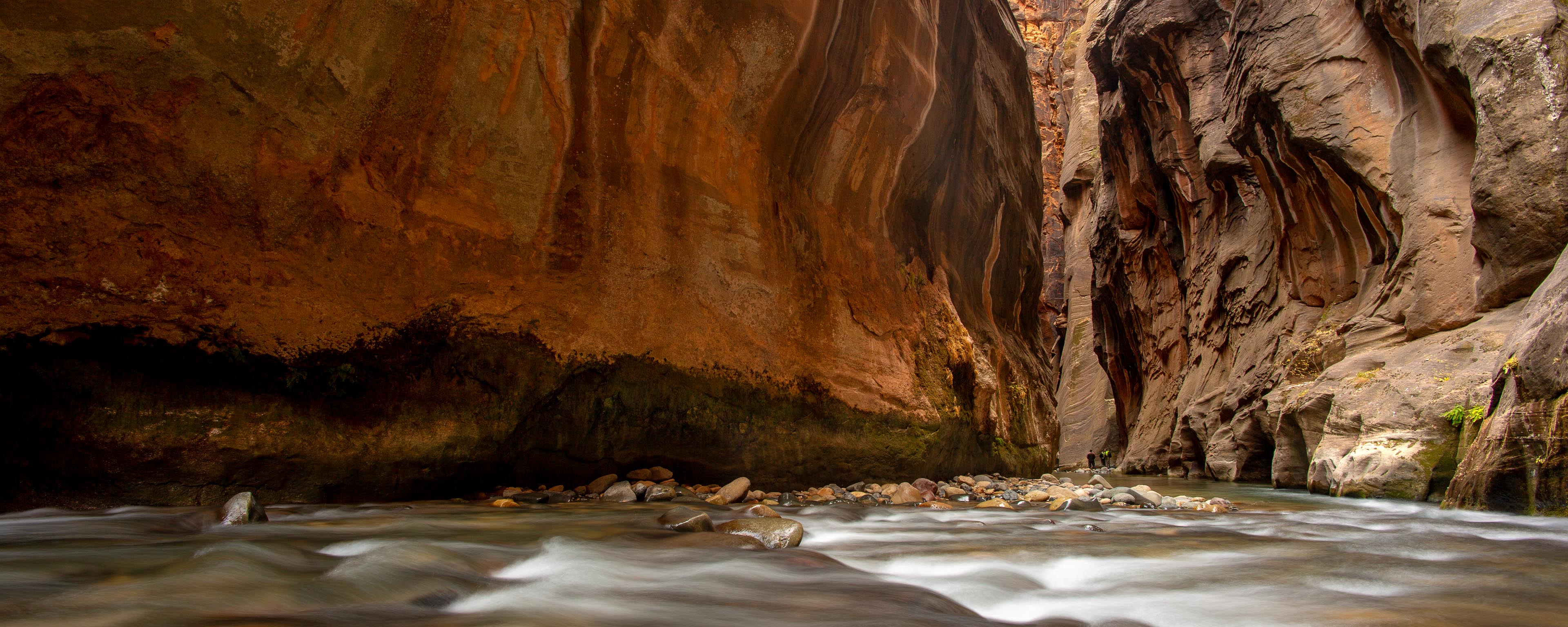
 The Virgin river flowing through the Zion Narrows
ZION NATIONAL PARK, in southwest Utah, preserves the most fairytale landscape
in the American Southwest, and offers some of the best day
hikes to be found in the region. I've visited all of the National Parks
and many of the wilderness areas in Utah and in my
opinion Zion is the one place you
absolutely should not miss on a trip to Utah. This page collects a few
photos and brief descriptions of the best Zion hikes.
Trailhead: The hike starts at the Temple of Sinawava trailhead, at the
end of the Zion Canyon Road. During the peak months (from April through October)
Zion Canyon is closed to traffic and access is via shuttles.
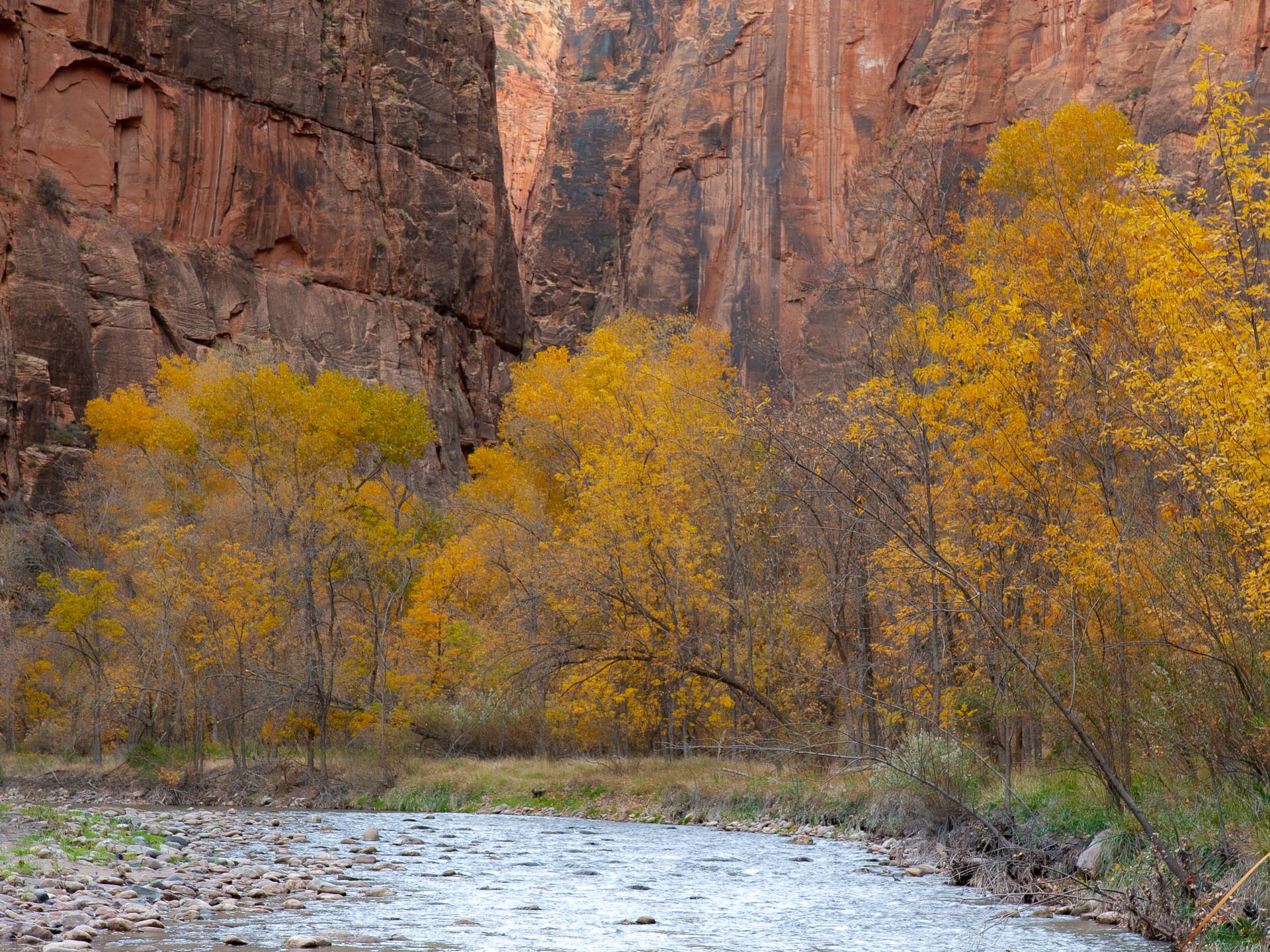 Zion's Riverside walk in Fall
 Hiking the Narrows, way back in 1999!
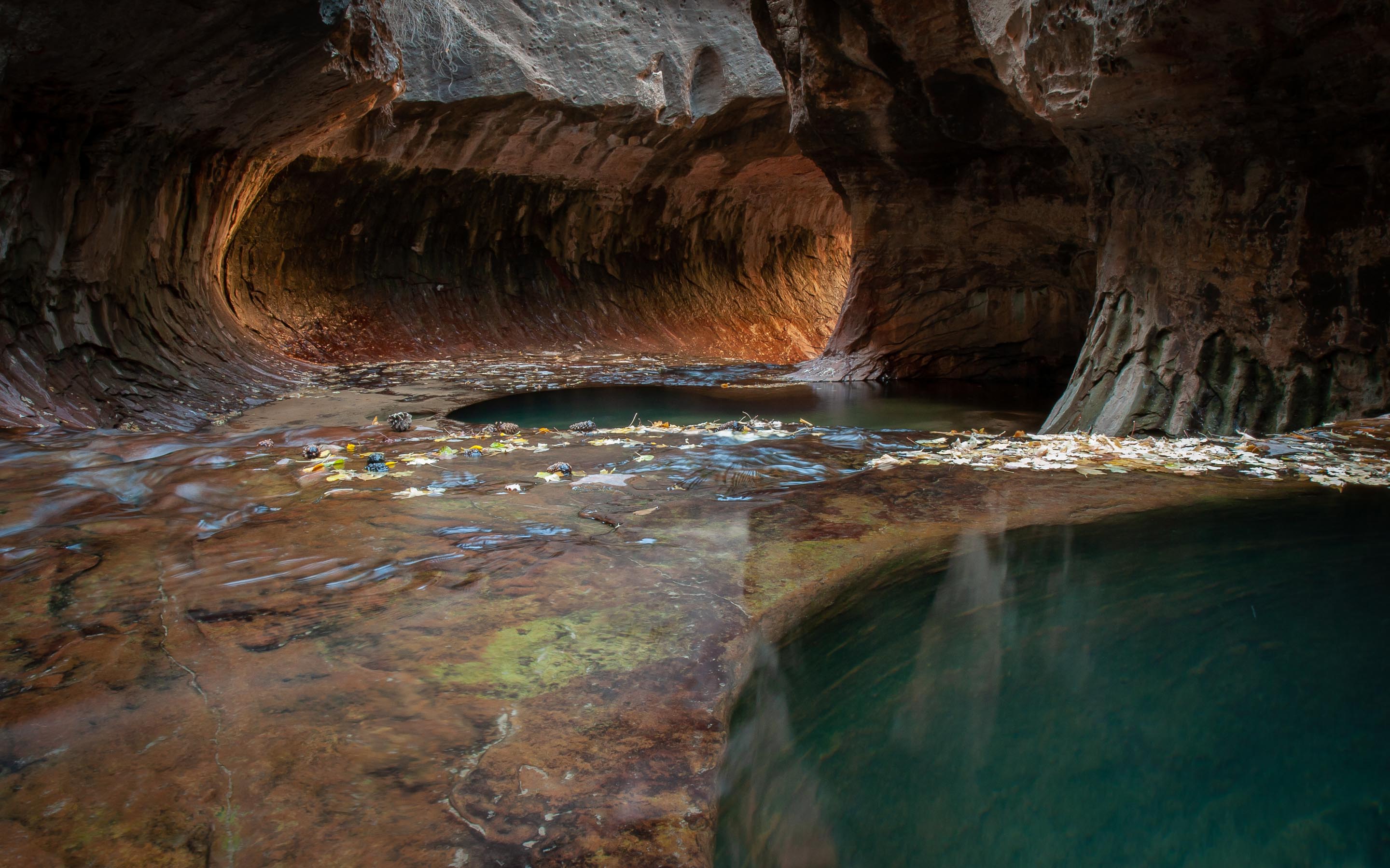
If the weather is amenable, a trip into the Narrows is undoubtably the
highlight of a visit to Zion. Beyond the end of the Zion Canyon road,
the Virgin River flows for several miles through a narrow gorge that
is perhaps a thousand feet deep but only thirty or so feet wide. The
narrowest sections, where the
river fills the canyon completely, are a majestic sight, and definitely
the most memorable part of my visits to the park. On a good day this
trip is popular, and depending on your tolerance for your fellow hikers
you might consider it crowded. It's the price to pay for one of America's
unique day hikes being so accessible, but it doesn't ruin the experience.
A full trip through the Narrows, going from North to South with the
flow of the river, is a lengthy one way slog of 16 or so miles that requires a
permit, and either a (long) day or an overnight stop. Spectacular sections
lie within a few miles of the end of the paved trail at the North
end of Zion Canyon, however, and these are easily reached on a day hike.
There's no trail as such, you progress upstream along the banks of the
river where they exist, with frequent fordings and extended stretches
of wading otherwise. When the river is at its lowest (50 cubic feet per second and below) it is generally possible to
stay within water that is not much more than knee deep, though you may run into some
waist deep spots. No swimming should be needed. Unless you
do more river wading in everday life than me, though, it still
feels pretty deep! The water-polished rocks that line the river bed make for
treacherous going - boots and a wading staff were
essential. One popular turnaround point is at Orderville Canyon, which joins the main canyon
close to one of the most impressive sections of Narrows. Orderville Canyon
can be explored for some distance itself, but although it's also an
impressively narrow gorge it's not nearly as interesting or
photogenic as the main canyon. If you're pressed for time I'd recommend instead
exploring further up the main canyon, ideally as far as Big Spring (which is where
the Park Service requests that day hikers stop).
The sole downside of this hike is that it's dependent on good weather.
There are three considerations: the warmth of the water (summer is best -
by November you'll need a wetsuit or even a drysuit for the legs, which you
can hire locally), the
water depth, and the risk of thunderstorms and flash
floods. Using historical U.S. Geological Survey data I've made a chart showing the
flow rate
of the Virgin River in "typical" and "moderately high water" years (for
statistical afficianados, this is the median and 80th percentile data).
The Park Service issues permits for through day hikes only when the
water flow is below 120 cubic feet per second, so taking this as a
limit on when the Narrows is hikeable you can see that in a typical year
the season starts in late May or early June, whereas in a high water year it might be July
before the snowmelt subsides. The video shows what the hike is like when the flow rate is
about 90 cubic feet per second. Also remember that although the
average
flow in July and August is low, these are also the months when storms pose
the greatest risk. All things considered, June, September
and early October are probably the optimum times.
The Park Service posts the weather forecast and local
flash flood danger in the visitors' center, and waiting for a favourable
forecast is essential. I've seen the Virgin River at a moderate
flood level after heavy thunderstorms and it was an incredible and sobering sight.
I certainly wouldn't have wanted to venture into the water under
those conditions, much less be stuck somewhere upstream in the
canyon.
Trailhead: The trail leaves from the Grotto trailhead in Zion Canyon. This is
another very popular hike so expect the trail to be crowded for most of the day.
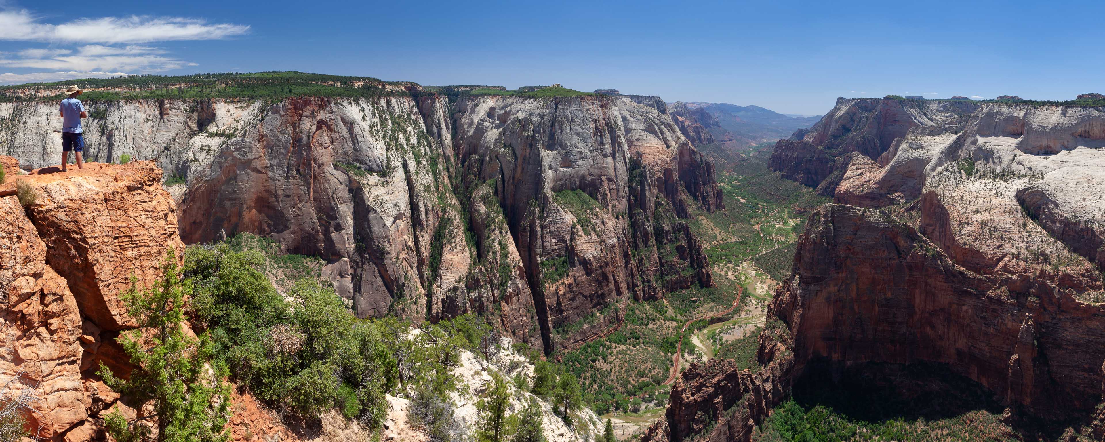
Zion's other signature hike is to Angels' Landing, a narrow sandstone fin
that juts into Zion Canyon from the West Rim. There are spectacular
views of the canyon from the top, but this is a hike - rather like Half Dome in Yosemite -
whose fame derives as much from the thrill of the route as the destination.
The trail first climbs steeply from the floor of Zion Canyon
up to and along a side canyon, before reaching a junction with the West
Rim trail at Scout Landing (left-hand photo below). From there, the route crosses a precarious
neck of rock - at one point just a few yards wide with sheer drops
on both sides to the canyon below - before climbing again to
reach Angels' Landing itself. Chains have been bolted into the rock
to provide handrails for the most exposed stretches, and there's no
real danger of slipping and falling except, perhaps, in wet or icy conditions,
which I wouldn't fancy. Having done this hike twice though - and watched many
people turn back at the narrowest section - it's clearly not a place for anyone
afraid of heights. The middle photo below shows the crux, which is quite short. Further up it's a lot
steeper but also less exposed. From bottom to top it's about 2.5 miles, and 1500 feet of ascent, with
excellent views almost all of the way.
 Scout Landing
 The narrowest section
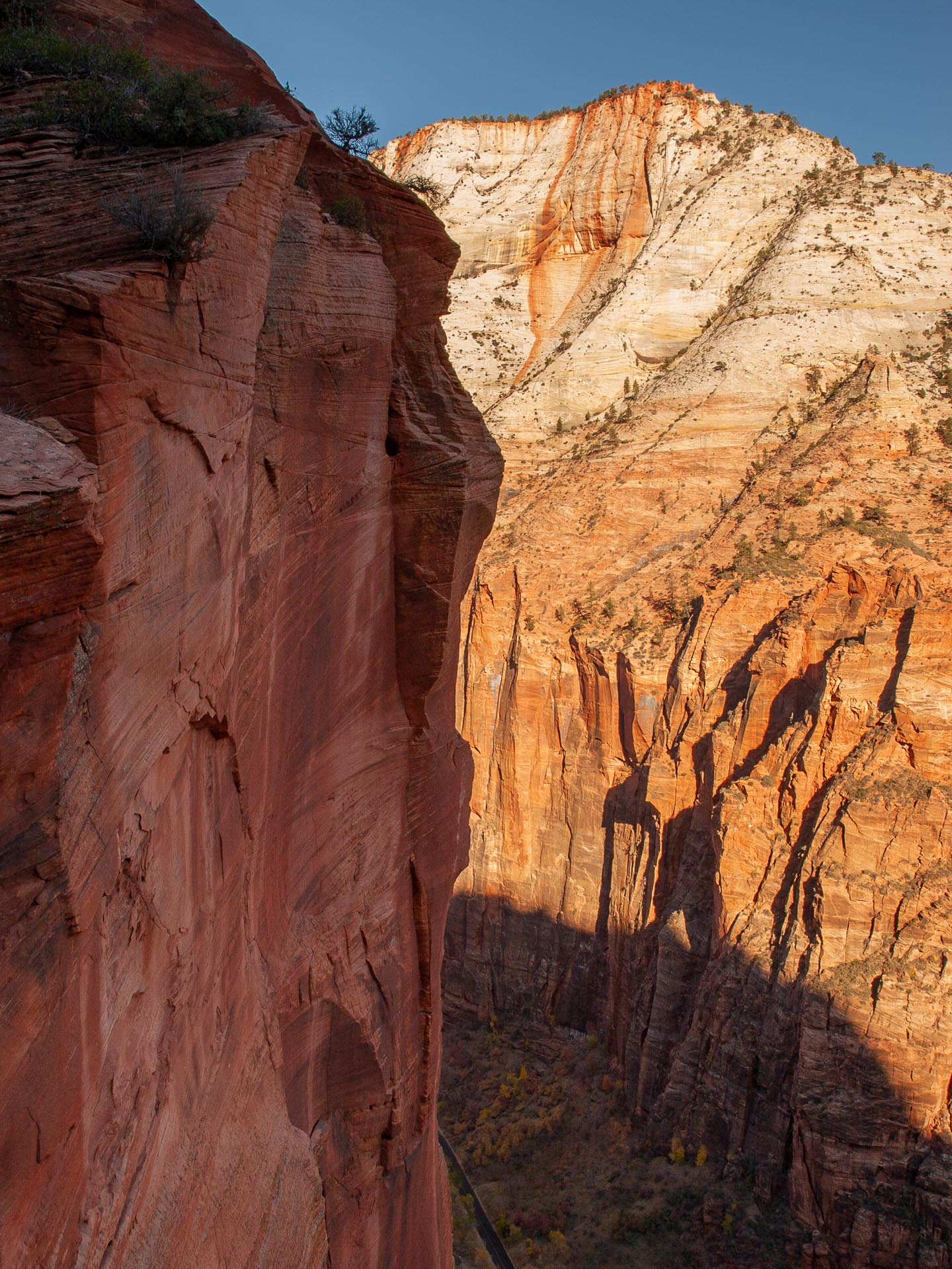
 Zion Canyon wall
I enjoyed both my trips to Angels' Landing, and on the second occasion had the unforgetable
experience of seeing endangered Californa condors soaring around the summit. Be warned, however,
that this trail is now extremely popular. Expect it to be crowded even out of peak season.
If either the exposure, or just the thought of hiking a steep narrow route with a lot of company,
is off-putting, there are two excellent alternatives. The Observation Point trail, on the other
side of the canyon, accesses equally good views but has far less in the way of exposure. The West
Rim trail, which meets the Angels Landing trail at Scout Landing, is longer (it's usually done as a
one-way shuttle trip) and much less crowded.
Trailhead: West Rim trailhead below Lava Point on the Kolob Terrace Road. The hike is usually done as a one-way trip, ending at the Grotto trailhead in Zion Canyon. Early morning shuttles leave from Springdale (these are private shuttles, not the Park Service ones, and need to be booked in advance).
 The very end of the West Rim hike - shared with the trail to Angels' Landing - sees the trail emerge into Zion Canyon
The West Rim trail is one of Zion's best options for a long, less crowded, day hike. It's most easily tackled as a one-way day hike (or short backpack), though the best scenery can also be seen on a more strenuous partial loop starting from the floor of Zion Canyon. When I did the hike, in early November, I opted for the one-way day hike option, which made for an outstanding and highly recommended day out.
The video below shows the hike. The trail starts among forested terrain, high-up in the Zion backcountry, and descends more or less steadily through different levels of Zion's geology to a finish on the floor on the main Zion Canyon. The scenery becomes steadily more spectacular along the way, beginning with a flat stretch through the trees with one or two overlooks, before dipping into and then out of a pleasant high valley. After exiting Potato Hollow the world-class scenery starts in earnest, with views into remote canyons, stretches of slickrock hiking, and sections where the trail traverses steep cliffs. A final climb reaches the rim of Zion Canyon, and a junction with the Angels' Landing trail at Scout Junction.
The West Rim trail is about 15 miles one-way, almost all of it downhill. There's a stretch of trail with substantial exposure on one side, though it's not as narrow as the narrowest point on the route to Angels' Landing.
Observation Point trail from Zion Canyon
Trailhead: Weeping Rock in Zion Canyon
Distance: 4 miles one way
 Looking down into Zion Canyon from Observation Point
The trail to Observation Point is Angels' Landing's less famous sibling on the eastern side of Zion Canyon. It's another
steep trail (the elevation gain is about 2150 feet) that attains an equally - some would say more - impressive panoramic
viewpoint over Zion Canyon. In summer an early start is recommended, as the upper reaches are devoid of shade. The scenery
along the trail is pleasant, though not as spectacular as Angels' Landing, but the route is less crowded. From the
top you have an outstanding overhead view of both Zion Canyon and Angels' Landing.
Zion Subway (bottom-up hike)
Trailhead: The Zion Subway is located along the rather prosaically
named Left Fork of North Creek. The non-technical out and back hike to the bottom of the
Subway starts at the Left Fork trailhead along the Kolob Reservoir Road. Note that
permits are necessary even for a day hike in this drainage. I had no
trouble securing a permit for a weekend in November (in fact I saw only two other
people all day), but in the summer advance planning is necessary.
 Fall colors along the Left Fork downstream of the Subway
 The classic, and rather short, Subway section
Anyone with even a passing familiarity with photography of the American
Southwest will have seen pictures of the Zion Subway - a beautiful undercut
section of canyon pitted with deep blue pools. Providing that you manage
to secure a permit reaching the Subway isn't difficult - it's a 4.5 mile
one way hike up the Left Fork of North Creek that takes maybe two and a half
hours. The hike starts at the Left Fork trailhead and, shortly afterwards, the trail
drops off the rim and descends steeply to reach the creek at the canyon floor. From
there, it's just a matter of turning left and following the creek
upstream to reach the narrow section. There's no formal trail, but although
the route requires some scrambling and thrashing through undergrowth
there's nothing that will deter the determined hiker. The lower reaches
of the canyon are pleasant but unremarkable - the spectacular scenery
is all concentrated within maybe half a mile of the Subway. You'll know
you're getting close when you start to encounter undercut walls and
attractive cascades where the creek flows over staircase-like slabs
of rock. At one spot much of the water flows through a narrow crack
just a few inches wide in the rock. Just beyond the crack there's an
imposing straight section beyond which lies the gloomy entrance to the
Subway. Hiking now up the creek, you turn the corner and find yourself
in the Subway section. Water flows across the whole canyon floor
here and the rock is very slippery - good footwear is needed to avoid
becoming part of the classic scene!
 Hiking from the bottom you enter the Subway from the left. The canyon slots up and becomes impassable just around the bend to the right.
Having reached the Subway, there's an almost irresistable desire to explore
the canyon further upstream. Alas, it can't be done. Just a few yards beyond
the spot where the classic photo is taken the canyon slots up, and futher
progress is blocked by a section that requires swimming and, immediately afterwards,
an unscalable waterfall. To see the upper reaches you need to descend the
canyon on a one-way trip starting from the Wildcat Canyon trailhead further up the
Kolob reservoir road. Although this is one of the easier canyoneering trips in
Zion, it still requires ropes and a willingness to swim through frigid water to
complete.
Trailhead: Lee Pass trailhead, about 4 miles along the Kolob Canyons scenic drive in the
northern section of Zion National Park. Carry plenty of water for this hike - although it's
not especially difficult there's
not much shade and the return in the heat of the day is mostly uphill.
 Zion's Kolob Canyons at sunset. The trail to Kolob arch starts here.
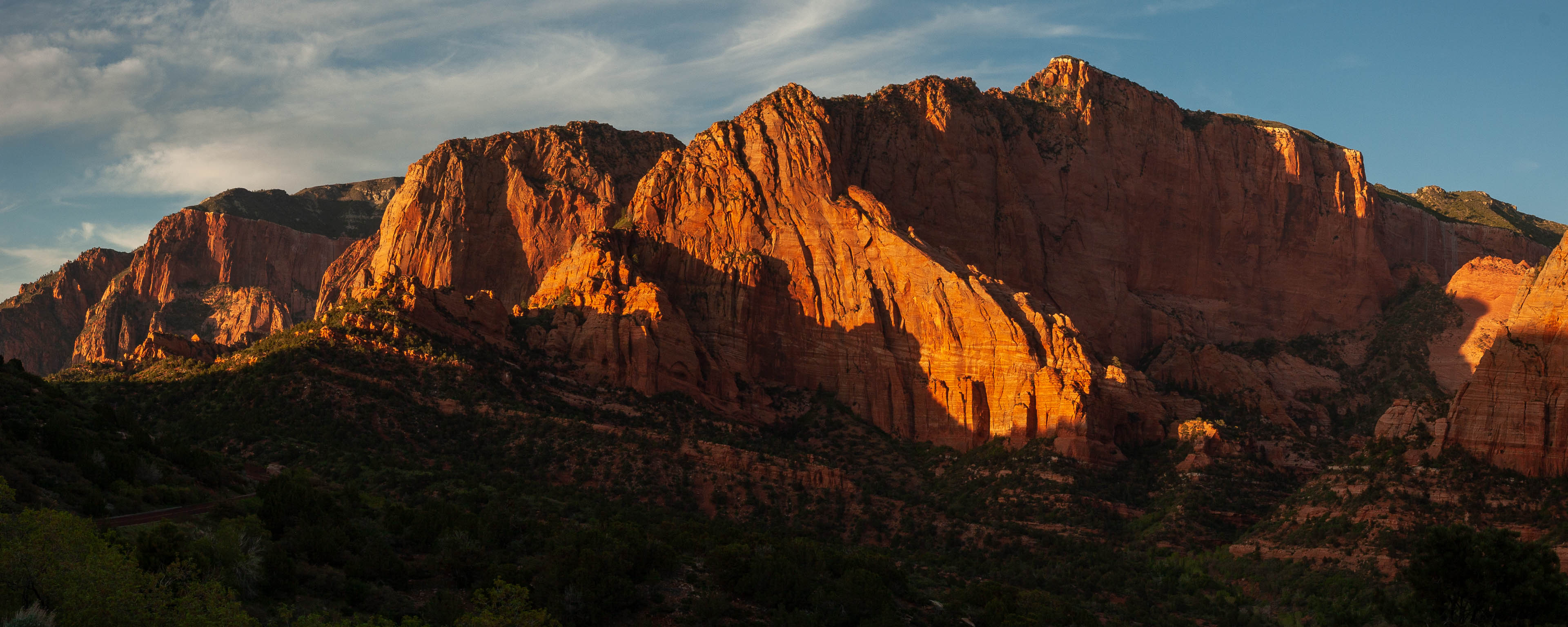
Although Zion Canyon is deservedly the centerpiece of Zion the Kolob Canyons are also beautiful and
well worth exploring - not least as an antidote to the crowds in the main canyon. Although the
northern section of park is easily accessed from I-15 just south of Cedar City (about an hour
from Springdale) the canyons here are relatively lightly visited. The short scenic drive
offers some of the best spots to view sunset in the park (the panorama above was shot from
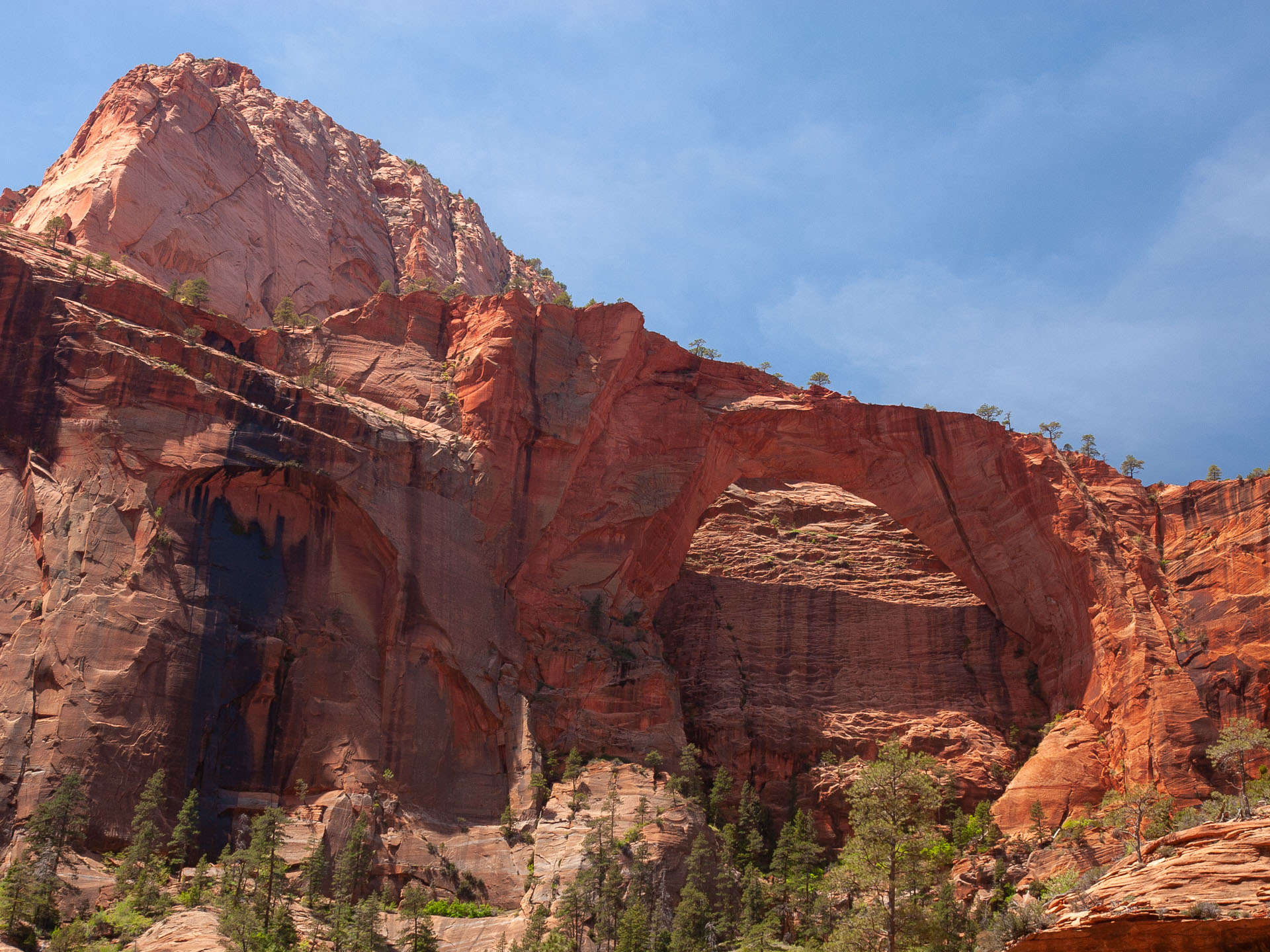
the road side near Lee Pass) and there are a number of good hikes. The best known is a 14.4 mile
out and back trip to view Kolob Arch, which vies with Landscape Arch in Arches National Park
for the title of longest arch in the world
(at least so they say, though how well scouted the further reaches of the world are for rock arches
one has to wonder). Having seen both I'd observe at the outset that Landscape Arch is a good
deal more spectacular than Kolob Arch, but nonetheless the latter is still an impressive piece
of stone and worth hiking to see.
 About the best view of the arch it's easy to obtain
 Hiking toward Kolob arch
Starting from the Lee Pass trailhead the hike to Kolob Arch is a trail of three halves. The first
mile or so runs parallel to the Kolob Canyons and offers excellent vistas as the trail descends to
the floor of the canyon to meet Timber Creek (remember that descent as reversing it will be
moderately tough labor at the end of the day!). The trail then follows Timber Creek for a while
before turning sharply east and descending further through some scrubby forest to reach La Verkin
Creek. This second section is frankly rather tedious, and a couple of backpackers I encountered here
offered up the concise and unsolicited judgement "it gets better"! They were right too, as once
you reach La Verkin Creek the rest of the hike to the arch is much more scenic and the trail,
although a bit sandy in places, allows for fast progress. Kolob Arch lies about half a mile
up a small side canyon and although you can't easily approach the base of the arch a rough
trail climbs above the official viewpoint to allow an unobstructed view of the arch and the
attractive canyon it's situated in. I stopped here for lunch and returned the same way (making
it back to the car after about 6 hours) but there are excellent camp sites situated along the
creek and there are other canyons in the area that you could explore as part of a backpacking
trip.
 Double Arch alcove
For a shorter hike in the Kolob Canyons area I'd recommend the easy trip to Double
Arch Alcove, which is reached by following the middle fork of
Taylor Creek a few miles upstream into spectacular country. The
creek is shallow, and easily forded when necessary, or you can just
walk upstream and ignore the trail altogether. Relatively few people seem to
hike this route, and the destination - Double Arch Alcove - is a
spectacular cave-like sandstone structure set in deep canyon
walls. It's a memorable spot, and there are wonderful colors in the late afternoon.
Recommended itineraries
If you're visiting Zion and are not terribly keen on hiking, the best sights are
all in or near Zion Canyon and can be seen in a single day. Take the shuttle bus
to the last stop at the Temple of Sinawava and walk the paved path into the start
of the Narrows, and then sample some of the many short walks along the floor of the
canyon. You won't be disappointed. Fall is probably the most scenic time in the canyon.
If, on the other hand, you're a keen hiker, there are too many must-do hikes in Zion
to hit in just a day or two. At least a 3 day itinerary is needed. The truly unique trip is the Zion Narrows, so I'd
recommend timing your visit for a period when there's a fair chance of decent
weather. You should also do at least one of Angels' Landing / Observation Point,
then the Subway (remember a permit is needed for that, so plan ahead) and maybe a hike
in the Kolob Canyons or a one-way trip along the West Rim trail (a shuttle service
is available that makes that possible). On a first trip to the Southwest, my advice
would be to spend more time in Zion and the Grand Canyon even if you have to
skip Bryce or somewhere else - it's that good!
Practicalities
The most convenient
base for visiting Zion Canyon and the southern section of the park is the small town
of Springdale. This attractive gateway has plenty
of motels and restaurants, including the highly recommended Zion Pizza and Noodle Co (I
recommend sharing their hearty pies unless you've been running laps up Observation Point).
Las Vegas is the nearest major airport (160 miles), while
the North Rim of the Grand Canyon (120 miles), Bryce Canyon National park (90 miles), and the Paria canyon
wilderness (about 50 miles) are not too far away either. If the motels in Springdale are all booked
(possible during the most popular weekends), it's perfectly possible to stay in the
rather larger towns of Hurricane or St George and drive to the park from there... it will be
cheaper and the drive will take
an hour or less. Wherever you stay, a car is
pretty well essential for getting anywhere in these parts.
Recommended references:
The official website for Zion from the
National Park Service
Current
flow rate of the Virgin River, from the U.S. Geological Survey
Joe Braun's guide to hiking in
Zion is the one I turn to
Hiking Zion & Bryce
Canyon National Parks (Falcon Guide).