 Lower Calf Creek Falls
The 1.7 million acres of the Grand Staircase - Escalante National Monument, together with the
nearby Paria Canyon and Death Hollow wildernesses and Capitol Reef National Park, contain some of the best
canyon hiking to be found in the Southwest US. Although the region is famous for its slot
canyons, backpacking trips, and technical canyoneering possibilities, the relatively sparsely
visited area also has easier trails that can be accessed out of the small towns of Boulder, Escalante and Kanab.
This page summarizes some of the best day hikes I've found in the Escalante.
Coyote Gulch via Hurricane Wash
Trailhead: Hurricane Wash trailhead, about 33 miles down the Hole-in-the-Rock
road from its junction with Utah 12 just outside Escalante. Road conditions vary, but on the occasions I've driven it this wide unpaved road was in great condition
all the way to the trailhead, and readily passable in a normal car. Allow about an
hour from Escalante to the trailhead. Watch out
for cattle wandering onto the road!
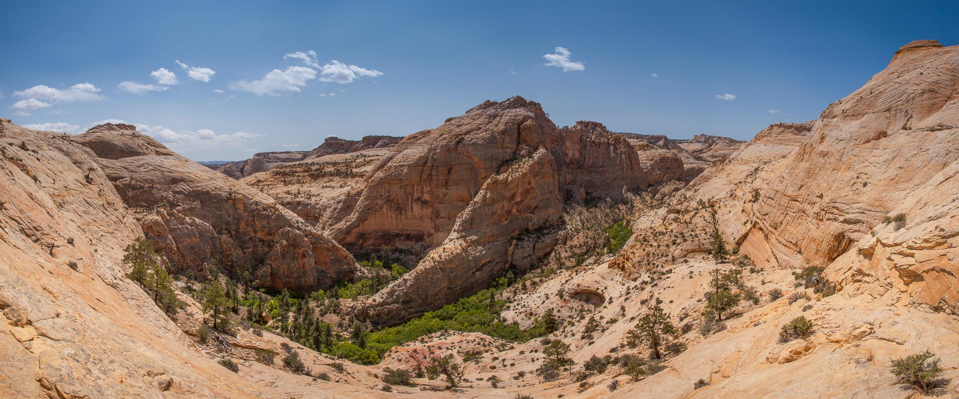
 Jacob Hamblin arch and the giant alcoves in Coyote Gulch
Exploring Coyote Gulch is at the top of most hikers' wish-lists in the Escalante, and
with good reason. The sinuous sandstone canyon features spectacular rock arches, deeply
undercut alcoves, and lush vegetation. It's a remarkable yet relatively easy to visit
place that as is every bit as impressive as better known canyons in Zion National Park.
For a day hike, the easiest access is via Hurricane Wash. A nondescript drainage at
the parking area, the wash rapidly deepens into a pleasant open canyon as you hike down the
normally dry streambed. It's easy if somewhat sandy and unremarkable going for the first three miles.
After passing the Glen Canyon Recreation Area boundary at the three mile point,
there's a short section of modest narrows before the canyon deepens
dramatically and water starts appearing along the floor. For the last couple of
miles before the confluence with Coyote Gulch the canyon is quite lush, and
it's easy to lose the main trail amongst the willows.
All this is pleasant enough, but the drama of the hike begins once you reach
Coyote Gulch proper at the 5.4 mile mark. Heading downstream, the Gulch
is marked by sweeping bends with huge undercut alcoves at almost every
corner. It's often easiest to hike in the ankle deep
stream rather than follow the trail. About one and a half miles down
canyon - 7 miles from the trailhead - you reach Jacob Hamblin Arch,
an impressive arch that cuts through the canyon wall where the stream
makes a sharp U-bend. Just beyond the arch there's an amazing alcove,
beneath which several backpackers had set up camp. We had lunch here and
returned, but there are no obstacles to continuing a further 2 miles
down the canyon as far as Coyote Natural Bridge.
The Hurricane Wash route gives the easiest access to the Gulch, but there
are other possibilities too. The lower part of Coyote Gulch, at the
confluence with the Escalante River near Lake Powell, can be reached
from the Forty Mile Ridge trailhead, a little further down the Hole-in-the-Rock
road. It's also possible to make a loop from the Forty Mile Ridge trailhead by
first heading to the lower Gulch, then hiking upstream and exiting the canyon near
Jacob Hamblin Arch. We didn't try this since guidebooks differ on the
difficulty of the exit route, with some suggesting that climbing experience
is necessary to exit safely.
Boulder Mail trail to Death Hollow
Trailhead: Along the McGath Point Road, which departs from the Hell's
Backbone Road immediately past the junction with Utah 12 southwest of Boulder, Utah. The
road is short but rough.
Trailhead parking is available just after the road crosses the Boulder Airstrip. Note that the trail now
leaves directly from the parking area (unlike in years past, when you had to hike down the closed road for a
mile or so before joining the trail proper).
 Looking into Death Hollow from the Boulder Mail trail
A great out-and-back hike that traverses the heart of the Box-Death Hollow wilderness, the Mail Trail is
one of the best slickrock routes in the Southwest. It follows the
route of the old mail trail (and still visible telegraph line) for about 16 miles between the towns of Boulder and
Escalante. The trail - much of which is marked only by cairns as it crosses the slickrock -
meanders across the upper reaches of the Sand Creek drainage for several miles before
reaching the rim of Death Hollow. There are some sandy sections that slow progress, but the
route is clear and the landscape dramatic. Death Hollow is a deep, imposing gorge, and the view from
the top is outstanding. The trail descends sharply for about 600 feet to reach the floor
of the canyon, some 5.5 miles from the trailhead. It's possible to explore Death Hollow in either
direction, though the vegetation is fairly dense (watch out for poison ivy) and you'll need to ford the modest
stream to do so.
More ambitious shuttle hikes are also possible, though I haven't tried them myself. With two
vehicles, you could do a one-way hike all the way from Boulder over to Escalante. That would
make for a long day hike, or you could camp near Death Hollow where there're good camp sites and
abundant water. An altogether more ambitious hike, bordering perhaps on a canyoneering trip,
continues down Death Hollow to its confluence
with the Escalante river, then heads downstream to the Utah 12 bridge which is 10 miles
(all uphill) by road from the Boulder Airstrip trailhead. This 20 mile hike, which involves
a lot of wading and swimming in the middle part of Death Hollow, is described in
Day's guidebook Utah's Favorite Hiking Trails. I'd avoid any of these hikes in
mid-summer or when storms threaten, there's no shade and neither the canyon nor the
exposed slickrock would be good places to be in a storm.
The Golden Cathedral in Neon Canyon
Trailhead: Egypt trailhead, at the end of the Egypt road
which leaves off the left of the Hole-in-the-Rock road 17 miles from the Utah 12 pavement just outside
Escalante. The Hole-in-the-Rock road is dirt but usually easily passable, while the 10 miles of the
Egypt road present more of a challenge: there's a short rocky stretch and several places where sand and
dried mud might cause grief after any rain. Use common sense, but in good weather I had no problems reaching the trailhead in a small 4WD SUV.
 Escalante's "Golden Cathedral" in Neon Canyon
The Golden Cathedral is a magnet for photographers and adventurers alike, and if you're familiar with the
Southwest you'll surely have seen pictures of it, often with beams of sunlight or canyoneers descending from the
holes in the roof (more remarkable is
this footage of water pouring
through the roof!). The Cathedral lies at the dead-end head of Neon Canyon (as it's informally called, on maps it's unmarked), a small
but beautiful tributary canyon off the Escalante. Assuming that your vehicle can reach the trailhead it's a
moderately difficult 4.5 mile (one-way) hike to reach the Golden Cathedral.
Orientation: The trickiest part of the hike to the Golden Cathedral is finding your way
down to the Escalante. There are two alternative non-technical routes, but neither option is 100% obvious on the ground and it's possible
you'll lose the trail temporarily. Before leaving the Egypt trailhead it's worth taking a moment with a map to orient yourself, since from
this lofty vantage two levels above the river the easiest route down can clearly be seen. You want to keep to the left of the south fork of Fence Canyon, which
can plainly be seen leading off toward the Escalante. Visible, but less prominent, is the north fork of Fence, which joins the south fork
shortly before it reaches the river. The simplest route down descends from the bench almost exactly at the tip of the inverted "V"
where the two branches of Fence come together. If you do lose the trail, track toward the rim of the south fork of Fence near the tip and
you'll easily find it again.
From the trailhead, a steep cairned route leads down the slickrock slope to the bench above
Fence canyon. Near the signed boundary of the Glen Canyon recreation area the trail divides, somewhat indistinctly, with both branches taking
different routes down to the Escalante in the vicinity of the mouth of Neon Canyon. We followed the left-hand trail, which tracks the rim of
the south fork of Fence until it reaches the point above the junction with the north fork. The trail is blazed by white hoof-marks on the
slickrock, and intermittently by cairns, and as long as you stay on route it's easy walking as far as the overlook where the two branches of
Fence - by now quite an impressive canyon - come together. From the point, a clearer cairned trail leads down into the tree-lined depths of
Fence, and in no time at all you find yourself on the banks of the Escalante, 3 miles from the trailhead.
If you're camping, there are good campsites both here, and a
short distance downstream along the river.
The final stretch to the Golden Cathedral is fun and easy. Taking to the water, which is normally
not too deep, there's a mile of river wading interspersed with sections of trail across the canyon floor to reach the mouth of Neon Canyon,
which is the first side canyon to join the Escalante from the left heading downstream. It's clear and would be hard to miss! From the
Escalante it's about half a mile of easy walking up Neon to reach the Golden Cathedral. It's a magical spot, equally as impressive to see in
person as in photographs. After savoring the experience, I returned the same way, but if you have more time there are other side canyons off
the Escalante in the vicinity that are worth exploring. Just a short walk further downstream the next drainage entering from the left leads
to Ringtail Canyon, a dark non-technical slot that's another favorite for photographers.
 Pine Creek Box, near Boulder, Utah
Trailhead: start at the signed "Upper Box access" about midway along the Hell's Backbone road between
Boulder and Escalante. This road is unpaved but poses no obstacles to any vehicle. For a one-way hike (about 9 miles), you'll want a shuttle car at the "Lower Box
access" closer to Escalante along the same road. An out-and-back hike from the top is also very pleasant.
The Pine Creek Box is one of the three main canyons that cuts through the Box-Death Hollow wilderness. Unlike the others - Death Hollow and Sand Creek
- which are beasts to descend, Pine Creek can be followed from top to bottom on a mellow day hike. Starting from the top, the canyon is initially intimate and
tree-lined, though it broadens and deepens into a more typical desert canyon a few miles downstream. The trail crosses the creek countless times,
though when I did this hike in mid-May it was generally possible to hop across without getting my boots wet. I'd rate this as a good hike. The scenery
is not the most spectacular you'll find in the Escalante but it's an enjoyable option, perhaps especially on a hot day since this route is high up and offers a lot
more shade than most of the other hikes featured here.
Trailhead: The trail to Lower Calf Creek Falls leaves from a prominently signed
picnic area / campsite off Utah 12 between Boulder and Escalante. The Upper Calf Creek
Falls trail parking is unsigned - look for a spur road between mileposts 82 and 83
nearer Boulder.
The very popular trail to Lower Calf Creek Falls is the best easy day hike in the
Escalante region, and makes a good introduction to the beauty of the Escalante
canyons. The almost flat 6 mile roundtrip hike to the Falls, along an excellent
trail, runs through a lovely canyon with some easily visible petroglyphs and
Native American ruins. The setting of the Falls is very attractive,
and makes a good spot for lunch.
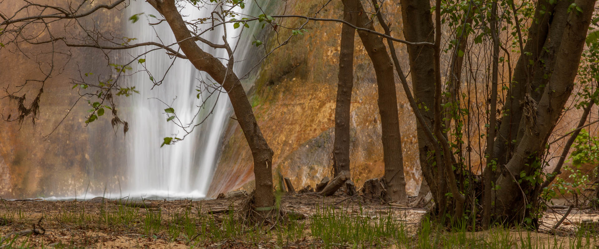 Lower Calf Creek falls
Contrary to what you might think, the Upper Calf Creek Falls trail does not go to the
top of the same waterfall you see from the Lower trail! It's a completely different spot
further up the same drainage. Upper Calf Creek Falls are less impressive,
but the 2 mile roundtrip across slickrock yields nice views across the
Calf Creek drainage. An oddity here is masses of black, volcanic boulders that
litter the slickrock.
Trailhead: Two trailheads provide easy access to the Upper Escalante Canyon.
Upstream, the short road to the Escalante Trailhead is signed off Utah 12 in the
outskirts of the town of Escalante. Downstream, you can access the river at the
Utah 12 bridge.
The Escalante river runs for 85 miles from Escalante down to Lake Powell. Coyote
Gulch is one of its tributaries, and many of the best hikes in this region follow
side canyons of the Escalante. The upper Escalante Canyon itself is very easy to
access, since there are trailheads both near Escalante and where Utah
12 crosses the river on its way toward Boulder. It's about 14 miles by trail
between these points, and a similar distance by road (though the highway
does not intrude upon the canyon except at the bridge). It's possible to
do a shuttle day hike along this whole stretch, or to explore from either
end on out and back hikes. In either case, wading shoes are useful - the
trail fords the river innumerable times. When I visited in mid-May, the
river was only ankle deep near Escalante, but more like shin deep downstream
near the bridge.
 Escalante natural bridge in the lower canyon
 Hiking in Upper Escalante canyon
The upper part of the canyon near Escalante feels deeper and more imposing.
It's pleasant hiking along the canyon floor, though the pace is slowed
by the frequent stream crossings and generally sandy trail. Starting from the
Escalante end there are
no particular landmarks until you reach Death Hollow (which can be
explored upstream if time permits) after about 7 miles,
but it's a beautiful canyon well worth savouring. Beyond Death Hollow
the canyon widens, and there are a number of Native American ruins and
rock arches, of which the most impressive is Escalante Natural Bridge.
The bridge is only 1.5 miles from the Utah 12 trailhead, so it can
easily be seen on a short day-hike starting from the lower end.
Paria Canyon and Buckskin Gulch
Trailhead: White House trailhead in the Paria Canyon / Vermillion Cliffs
wilderness. The short dirt road to the trailhead is about 30 miles northwest of
Page, Arizona, or 42 miles east of Kanab, Utah. Note that Kanab is about 120 miles from
Escalante - the base for the other hikes described on this page.
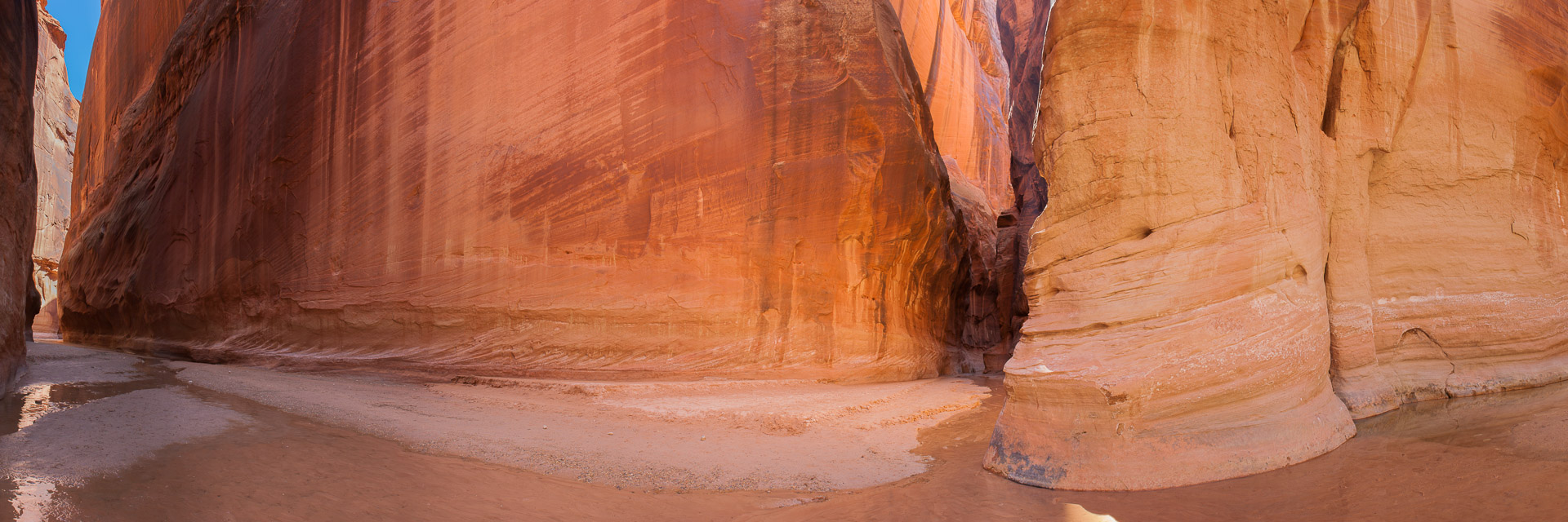 Looking into Buckskin Gulch at the point where it meets Paria Canyon
Although not in the same region as the Escalante hikes described here, if you're
going to this part of Utah you should at least consider a trip into
Buckskin Gulch and the Paria Canyon. It's a contender for the title of best
non-technical narrow canyon hike in the Southwest. Although I beg to differ
(my vote goes to the
Zion Narrows) there's no
doubt that a hike into the Paria and (especially) Buckskin is a unique experience.
The Paria River - which is often dry in its upper reaches - flows from the region
south of Bryce Canyon down to a confluence with the Colorado at Lees Ferry not far
from the Glen Canyon dam. About
7 miles downstream of the White House trailhead (and 30 miles above the Colorado)
lies the confluence with Buckskin Gulch, seen in the panorama above with the Paria
flowing from right to left past the entrance of the Gulch. It's
a truly memorable meeting of deep narrow
canyons in a remote and unspoilt wilderness setting.
This is the must-see section of the
Paria.
There are several options for hikes in the Paria Canyon / Vermillion Cliffs wilderness.
I did an out-and-back hike down the Paria to the confluence with Buckskin Gulch starting
from the White House trailhead just off Highway 89. At the trailhead the Paria is a
broad dry (in early June) wash, which steadily narrows and deepens as you hike downstream.
There's no trail and some sandy sections to slow progress, but it's impossible to get
lost as there's only one small side canyon. The Paria Narrows begin at about the 5 mile
mark, and from there to the confluence at 7.2 miles the canyon is consistently narrow with sheer
red sandstone walls. It's very pretty, but nonetheless on reaching the confluence
my immediate reaction was I'm hiking in the wrong canyon! If the Paria is
attractive, Buckskin Gulch is simply spectacular - a true slot canyon (in places you
can touch both walls) with a small year-round stream and sculpted walls. I hiked
up Buckskin a further 1.5 miles, past innumerable twists and turns, as far as a small
rockjam that presents a minor obstable where a rope is needed. I returned the same way back
up the Paria (now very hot in the upper more open section) which made for a 17 mile
day in all.
Escalante accommodation and dining
For most of these hikes, the most logical places to stay are in Boulder, Utah,
or Escalante. These are
small towns. Boulder has about 200 residents, Escalante about
800. I've stayed in Boulder at the
Boulder
Mountain Ranch (small, good value, and recommended), and at the
Boulder Mountain Lodge (which has large rooms, and
is also recommended). For dining, the high end option is the
Hell's Backbone Grill, which
has a beautiful setting.
The
Burr Trail Grill, next door,
is simpler and cheaper, but serves decent burgers and beer. All told there
are 3 or 4 places to stay in Boulder, and a similar number of restaurants and shops.
There's more going on in Escalante, including an outdoor store that sells
guidebooks, maps etc. The Paria Canyon / Vermillion Cliffs wilderness is
closer to Kanab or to Page (in Arizona), both of which are rather larger
towns.
When to go? The summer months are
hot, which together with the
obvious dangers of venturing into narrow canyons with thunderstorms
around make late June / July / August less than ideal times. There are
higher altitude hikes you can do in the summer - for example on Boulder
Mountain - but you wouldn't travel a long way for them alone I think.
Spring and Fall are probably best. I've visited in late March and in May, which were fine, though
the weather is variable: I've experienced both hot temperatures and snow in different years
in May. Out of season (even into May on
occasion) snow at the higher
elevations might make it hard to get to the region, especially if you're coming from Denver
over the high mountains.
Recommended references:
Hiking Grand
Staircase-Escalante and the Glen Canyon Region by Ron Adkinson
Hiking the Escalante by
Rudi Lambrechtse
Utah's Incredible Backcountry Trails
by David Day
