 Denali from the Eielson Ridge trail
THE FIRST problem with hiking in Alaska is knowing where to start. The
57 million acres of Alaskan wilderness is more than the rest of the US put together, but guidebooks, trails and even roads are
sparse in much of the state.
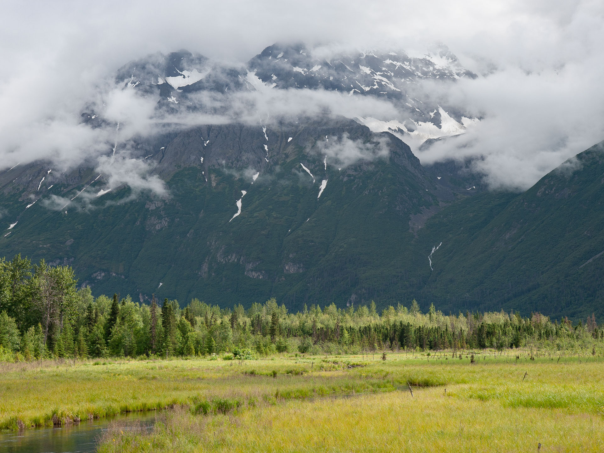
There are trails in Alaska, however, especially in the Chugach
mountains near Anchorage, on the Kenai peninsula, and around Juneau, and the hiking and scenery even in these "tame" wildernesses matches
or surpasses the best hikes I've done in the lower 48 states. This page
summarizes some of the best day hikes that I found within a day's drive of
Anchorage.
Harding Icefield trail, Kenai Fjords National Park
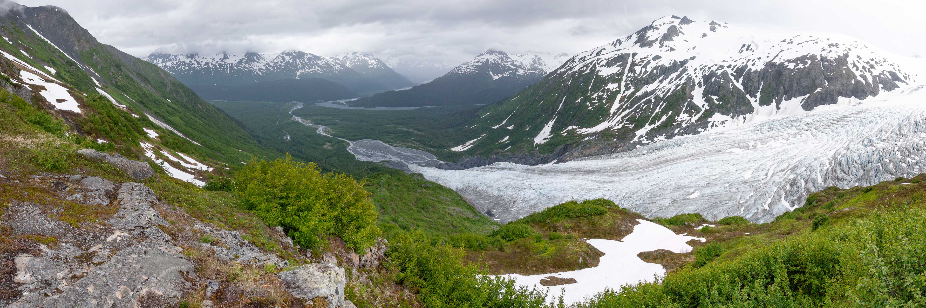 The Exit Glacier flowing off the Harding Icefield, Kenai Fjords National Park
Trailhead: Harding Icefield / Exit Glacier trailhead, in Kenai
Fjords National Park. The park is a short distance from the town
of Seward, about 120 miles south of Anchorage.
Distance: 8 miles round trip, with about 3,000 feet of elevation to the
overlook of the Icefield.
The hike to the Harding Icefield is the only real trail in Kenai Fjords National
Park, but what a trail it is! This is one of my favorite hikes in Alaska, and even if you're
staying in Anchorage it's well worth driving the 120 miles or so to the park just for this hike.
The drive is scenic in its own right. The upper reaches of the trail are covered
in snow for much of the summer (certainly in late July when I did the hike), but
the route is well marked and popular enough that this doesn't pose any particular
problems - the trail is slippery in places but can be tackled without special
equipment.
The trail starts at the Visitor Center near the terminus of the Exit Glacier and climbs along the side of the valley above the
glacier to reach its source at the Harding Icefield. The trail is well constructed but
indisputably steep, especially for the first mile and a half or so that it takes to climb
above the tree line. Good views start
at the 1.3 mile mark at Marmot Meadows where, on the day we did the hike, one of the eponymous critters was
contentedly basking on a rock just by the trail. From there, the trail ascends to the Top
of the Cliffs overlook at 2.3 miles - from where the panoramic vista of the
Exit Glacier above was taken - before continuing somewhat less steeply to an
emergency shelter and the icefield overlook that marks the end of the hike. An icefield
makes a difficult photographic subject - a sheet of white nothingness - but when you're there
in person the views of the glacier, together with the panorama of peaks in the coastal
mountains and the icefield itself stretching off into the distance, are extraordinary.
 Peaks in Kenai Fjords
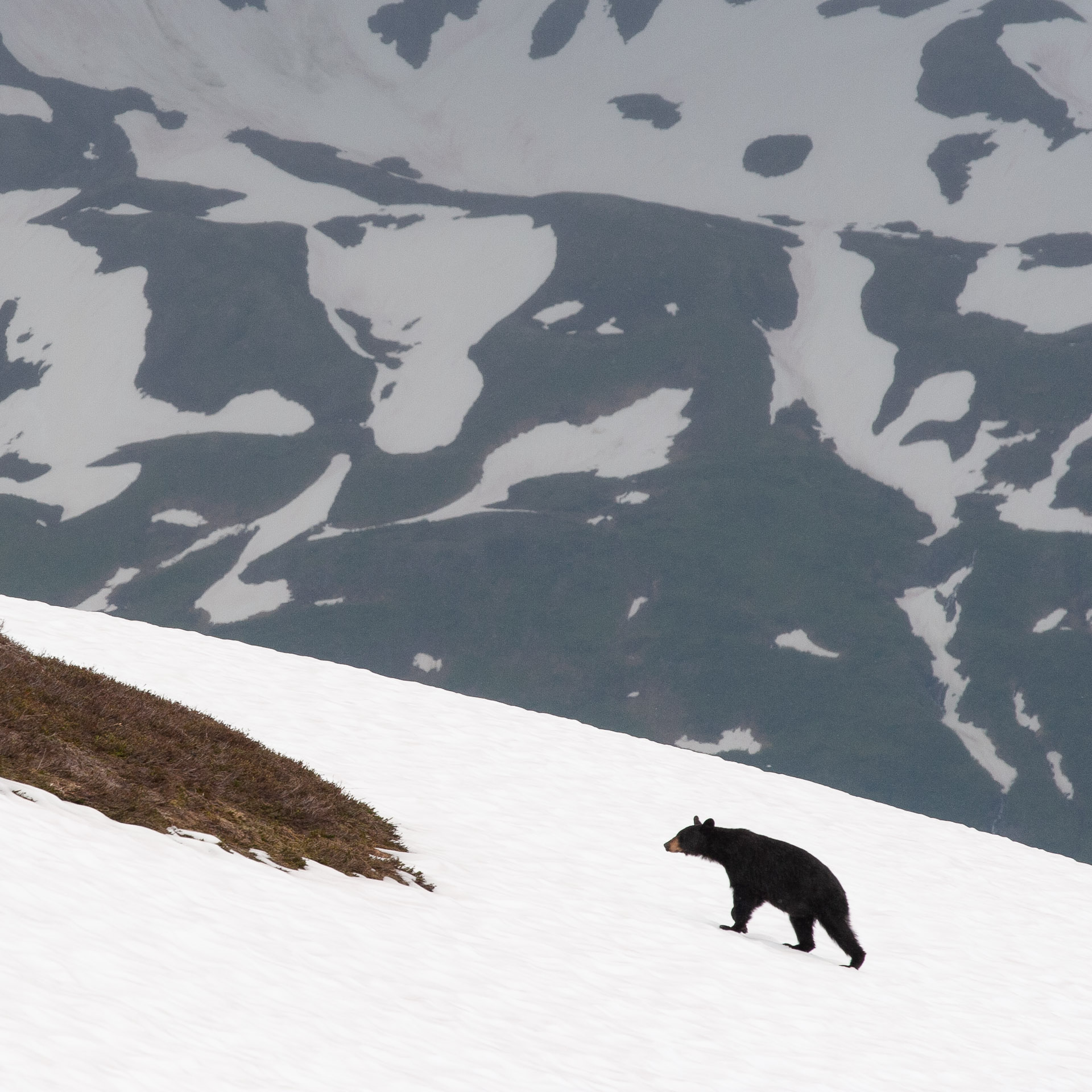 Bear on snow slopes above the trail
Bears (both black bears and brown bears) are
commonly sighted in the Exit Glacier area, and we saw a number of black bears
foraging in the area and crossing the snow slopes above the trail. The bears were
surprisingly nimble on the snow.
Crow Pass trail to the Raven Glacier
Trailhead: Crow Pass trailhead, about 45 miles from Anchorage. From Exit 90
on the Seward highway, head north 2 miles, then turn left onto Crow Creek road (unpaved, but in good condition). Fork right
after the bridge about 5 miles in to reach the parking area.
Distance: 8 miles round trip, with about 2,000 feet of elevation to the
pass
 Hiking the Crow Pass trail
 View approaching Crow Pass
The Crow Pass trail combines a historic flavor - this was the route of the Iditarod trail between
Seward, Knik, and Alaskan gold mining areas - with spectacular and varied scenery. The highlight is the Raven Glacier, which, although not enormous by
Alaskan standards, has a great backcountry setting. The trail is well-maintained, and in season (mid-June to September, depending on the extent of winter
snows) this is a popular, moderate day hike that I'd highly recommend.
The Crow Pass trailhead is already at moderate elevation, and it takes only a short time to clear the trees and
emerge onto the slopes of the Crow Creek valley. From there, it's a basically straight route up the valley to reach the pass at its head. There are a couple
of different trails, a lower route that passes some old mining detritus and a small waterfall, and a slightly easier route that cuts higher along
the east side of the valley. The junctions are easy to miss, but as long as the creek above the waterfall is easy to cross (as it was for us, doing the
trail in mid-July) it doesn't really matter which route you take. Reaching Crystal Lake at the head of the valley, the climbing is over, and the trail
continues gently over the pass to reach the Raven Glacier and a view down along Raven Creek toward the Eagle River valley.
We did this hike on a damp and overcast July day, which did nothing to lessen its scenic
attraction (in fact, the low cloud and swirling mist made for a magical scene resembling nothing so much as the Lord of the Rings).
It was, however, cold at the pass and the glacier! Take plenty of layers...
 The Raven Glacier from the Crow Pass trail
Backpacking option: The trail continues past the Raven Glacier, descending first Raven
Creek (at left in the panorama above) and then the Eagle River drainage to emerge at the Eagle River Nature Center north of Anchorage. The shuttle backpack is about 26 miles, requires one unbridged stream crossing, and involves less climbing if you start from the Crow Pass trailhead end.
Pioneer ridge trail to Knik glacier overlook
Trailhead: The trailhead is about 4 miles along the Knik River Road,
off the old Glenn Highway maybe 30 minutes drive north of Anchorage. There's a
small fee for parking. The paved Knik River Road continues further up the valley,
but there's no view of the glacier to be had from the road.
Distance: 9 miles round trip to the ridge, though it's possible to continue further to the
South Summit of Pioneer Peak. The trail is dotted with a number of picnic tables but
make no mistake - it's steep! It's about 5000 feet of climbing to
reach the ridge and the best views, from where the panorama below was taken.
On a wet and cloudy day this hike is good only for testing your fortitude and that
of your equipment. Although the trail is well-maintained, it is steep, slippery, and
punctuated by stretches of boot-sucking quagmire. Most of this is true whatever the
weather, but on a clear day the outstanding panorama of peaks visible from the
Pioneer Ridge more than compensates for the effort required to make the climb. Once
you clear the trees and bushes that clog the lower slopes of the mountain
the Knik glacier, 25 miles long and several mides wide at its terminus,
dominates the view toward the high peaks at the head of the valley. It's an
exceptional sight, made all more remarkable for its proximity to the city
of Anchorage.
Note: from the map it's clear that an even better view of the Knik
glacier would be possible if you could climb either Knik mountain or Hale-Bopp
peak starting further along the valley. The road goes far enough and the
climbs are said to be straightforward once you get above treeline. Access though
is tricky - the land in the valley is privately owned, some of it (apparently)
by survivalist types not keen on visitors.
East Twin Pass trail, Eklutna Lake
Trailhead: The Twin Peaks trail leaves from the main parking area at Eklutna Lake. There's a fee for
parking, and a bike rental shop at the trailhead.
Distance: 7-8 miles roundtrip to East Twin Pass, with about 3500 feet of elevation gain.
 Eklutna Lake from the trail
Heading north from Anchorage, three successive valleys offer hiking possibilities: Eagle River, Eklutna Lake,
and the Knik River. Eklutna Lake makes for an attractive destination, and if you're looking for an easy day hike or bike ride a trail runs along the
shore of the lake for some 15 miles toward the Eklutna glacier at its head. More strenuous hikes ascend the valley slopes for expansive
views of the lake and surrounding peaks. We did the East Twin Pass trail, which starts as an excellent (and only moderately steep) trail that ascends to a
great view out over the lake, before continuing to reach the tree line in a high side valley to the north. We saw a moose on the trail here. The
maintained trail ends at a bench about 2.5 miles and 1600 feet from the trailhead. From the bench, a much rougher path heads initially downhill to
cross the creek, before ascending to East Twin Pass. This last part of the route is clear and east to follow, but brutally steep. The view into the Matanuska Valley from
the the top isn't quite enough reward for the effort, in my opinion, but it's still excellent. We had lunch here and returned, but it's also possible to
ascend the ridge further in either direction, though bagging either of the Twin Peaks is a more technical endeavor.
If you have (or rent) a bike, an alternative is the Bold Peak hike, which leaves from a trailhead about 5
miles down the lakeshore trail. The trail is of similar difficulty to the East Twin Pass trail (about 7 miles roundtrip from the lake, with
3500 feet of climbing, and although I haven't done it I suspect it offers better views.
Portage Pass trail to Portage glacier and lake
Trailhead: The trail to Portage pass and on to the lake is close to the town
of Whittier, 75 miles from Anchorage. Coming from Anchorage via Portage the trailhead comes shortly after
you exit the Anton Anderson Memorial tunnel (one way and shared by cars and trains, so entertaining in
its own right) - take the first right across the railroad track onto a dirt road and then a
second right past a cinder block building to reach the signed trailhead.
Distance: About 4 miles roundtrip to the lake. The trail to the pass is moderately
steep but well maintained, whereas the trail down to the lake is steeper. On our visit, now a long time ago,
the path showed no sign of having seen a trail crew in many a year.
 The Portage glacier
This is a short hike to a magnificent close-up view of the Portage glacier.
Starting from the trailhead a good quality trail climbs briskly to Portage pass, which
offers a good view of the namesake glacier and lake. The pass makes a good destination for
a short and easy day hike. If you have even the slightest spirit of adventure, however,
you'll want to reach the shore of the lake, which is a different matter altogether.
There is a trail, but when we did the hike it was heavily overgrown and in danger of succumbing to erosion
into a deep gully in numerous places. Good luck if you run into a bruin here!
On a wet day - and Whittier is a
very wet place - expect
to get absolutely sodden. For all that I enjoyed this hike a lot, and having finally
reached the lake we had the view all to ourselves... until that is a tour boat
from down the lake showed up!
Eagle river valley trails
Trailhead: The trail starts at the Eagle Valley Nature Center, a short distance
north of Anchorage. There's a fee for parking.
The Eagle River Valley is quite attractive and there are a variety of short loop hikes you can do close
to the Nature Center. We saw a woodpecker here, and later in the season bears congregate
to fish along the river, so there's a chance of seeing wildlife. You can hike
as far as you want along the valley but it's miles of rather tedious
trudging through
trees before you get to the best views. If you want to see the glaciers at the head
of the valley, you're better off starting at the other end of the old
Iditarod trail and ascending to Crow Pass.
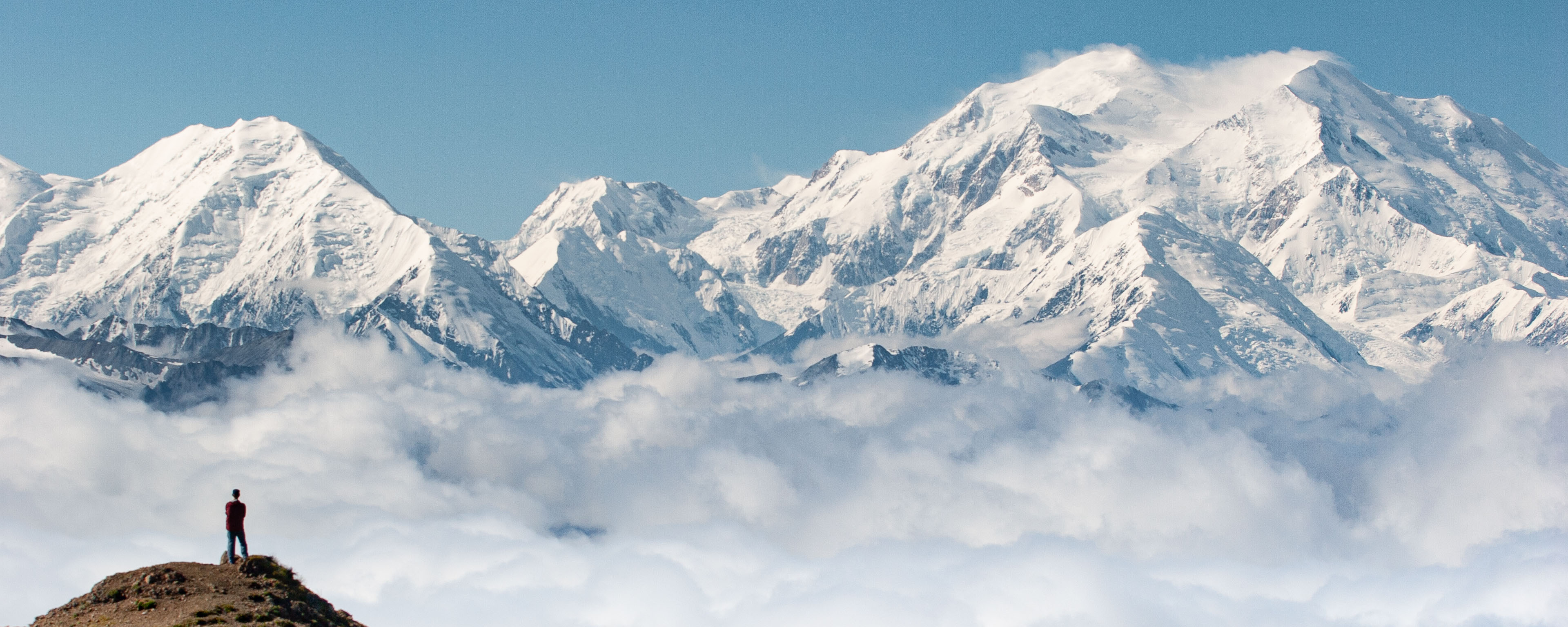
Eielson ridge trail, Denali National Park
Trailhead: the hike starts from the Eielson visitor center in the
interior of the park, at mile 63 along the park road. The road is closed
to private vehicles, so you'll need to book a shuttle bus going at least
far as Eielson to do this hike. Taking an early bus maximizes the chances
of seeing wildlife along the way.
Distance: it's just one mile on a fairly steep trail to reach the ridge
above the visitor center. It's then possible to walk for miles on informal trails
(or simply across the open alpine area) in either direction along the ridge.
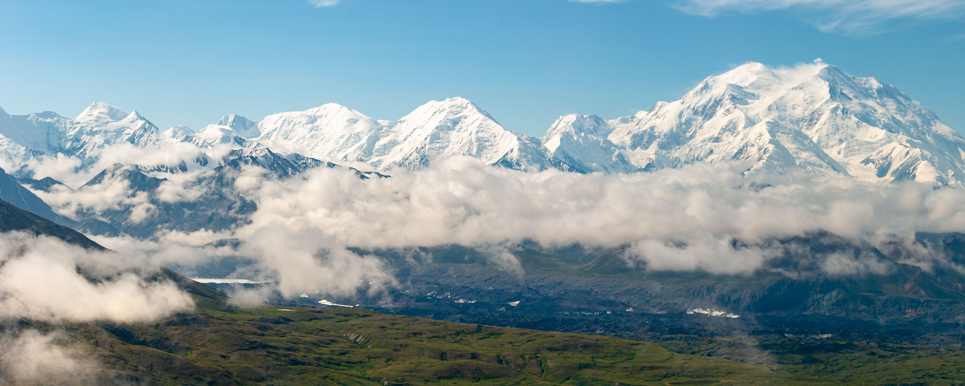 Looking toward Denali from along the Eielson Ridge
Including hikes in Denali on this page is something of a cheat - Denali National
Park is within an easy day's
drive of Anchorage but you can't do a day hike there while sleeping in the city. Nonetheless Denali is, with good
reason, high on most visitors' Alaska wish-lists, and I'd highly recommend you try and visit if at all possible.
The interior of Denali National Park is often described as being trail-less but it's
not really true - there's a formal trail up to the ridge above the Eielson visitor
center and other places where informal but clear routes exist. Eielson is about as
close to Mount McKinley as you can get along the park road, and from the visitor
center or from the ridge the view of the mountain is incredible. When I did this
hike low clouds obscured the view from the visitor center, making the appearance of
the mountain as we reached the ridge all the more dramatic. The formal trail ends
at the ridgeline, but it's easy to hike in either direction along the ridge and it
would be quite possible to spend half a day (about all the time one has given the
bus schedules) doing so. One should be aware that the mountain is frequently
lost in clouds (we saw McKinley for all of about 3 hours in 4 days spent in the vicinity),
so I'd advise spending some days in Denali to at least give you a fair chance of
getting a view.
The bus system in Denali is simply excellent (and given the state of the road,
you might not want to drive it yourself even if it were allowed!) and you can
get on and off the shuttle buses almost anywhere to go for a hike. Much of the
terrain - for example along the Toklat valley and near Thorofare pass - is
invitingly open, and the only significant impediment to hiking is the difficulty of
crossing streams. If I return to Denali, cross country hiking will be at the
top of my priority list.
It goes without saying that the main season for hiking in Alaska is summer, with
late summer (toward the end of August) probably being the optimum period as far as
weather, mosquitos and color goes. Whenever you go I'd recommend going prepared for rain.
For hikes in Chugach State Park you can stay in Anchorage, which is close enough
to Whittier and Seward that driving there for day hikes is straightforward. It's
worth staying downtown in Anchorage, where there are a number of decent pubs and
restaurants (I'd second the ubiquitous recommendations of Humpy's Great Alaskan Alehouse).
Denali National Park is about 230 miles north of Anchorage. Denali is not close to any large town -
you can stay either at the
park entrance (where there are some large hotels and a few reasonable restaurants) or in
very small places such as Healy a few miles down the road.
Seeing wildlife is a prime attraction of visiting Alaska, but can be a concern when out
hiking. Although I've not seen a brown bear from the trail, there are few if any Alaskan hikes where a bear encounter is not
possible. We've followed the standard advice which is to make plenty of noise, especially when visibility is limited, and
carried bear spray. You'll also see locals carrying guns, which is pretty normal in Alaska but initially surprising if you're
from Europe! If, on the other hand, you want to see bears I'd recommend either the bus tours in Denali, or visiting one of
the managed bear viewing sites. The video below shows a visit I made to Pack Creek,
flying by float plane from Juneau. It was great fun!
